People talk about fishing the thermocline, but most anglers have no idea what it is, why it should be fished or how to find it.
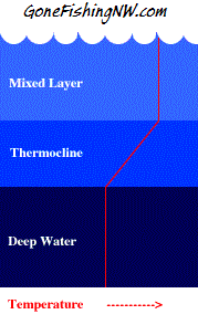
Simply put the thermocline is a band of water where there the temperature changes rapidly from hot on top to cold below. It is often several feet thick.
Due to the properties of water at different temperatures this forms a barrier which prevents the hot water on top from mixing with the cold water underneath.
Here is a diagram which shows what it looks like:
Why is this important to fishing. There are 2 reasons.
The first is the preferred temperature of the trout we are targeting. The second is oxygen content.
The water above the thermocline is too hot for the fish to be comfortable, or even survive for long periods of time. This is because the surface water gets exposed to all that sunlight.
However the water below has a low oxygen content for the fish. This is because the oxygen gets in the water by water plants and surface action. The water plants are usually shallow which places them above the thermocline. The thermocline forms a barrier for that oxygen to make it down to the below.
So the fish like to hang out around the thermocline. This allows them to find the balance they want of oxygen and temperature. With very little effort they can move to adjust that balance.
They will leave the thermocline in search of food, or to avoid predators, but will return to that layer before long.
The thermocline changes depths, but does so slowly – over weeks and months. It doesn’t change significantly during a day, or one day to the next. It is also the same depth for the whole lake.
This means that once we locate it we don’t have to search for it again until some time has passed.
The most surefire way to find the thermocline is to use a thermometer. Methodically try different depths until we find a band where the temperature changes quickly. Typically this happens with the water is around 55 degrees.

However what can we do when we forget to bring a thermometer?
Fortunately for us the lakes have a yearly cycle that once we learn can give us a good guess as to where the thermocline is.
Each lake is a bit different in how quickly it warms, and cools so the depth of the thermocline will be different lake to lake for a given day. However the general cycle stays the same.
To illustrate the cycle for our lowland western Washington waters lets consider Lake Sammamish.
Starting in May there is no thermocline and the surface temperature is in the mid 50s.
By the time June rolls around the water at the surface will start reaching the high 60s and a thermocline will be forming a few feet down.
As the water continues to warm that thermocline will go deeper and deeper. By the end of August it will be roughly 30 feet down.
As we head into fall the water temperature holds fairly steady, but by the time October comes the surface will be cooling and that thermocline will be coming back up.
By January the thermocline is gone and the water is the same temperature top to bottom. It will continue to cool until spring when it starts to warm again – starting the cycle again.
Once you figure out the specifics of this pattern for your favorite lake, then you can leverage that information year after year without having to remeasure every trip.
Comments are closed.